Delhi and Gurugram colder than Shimla: What is driving this unusual winter chill
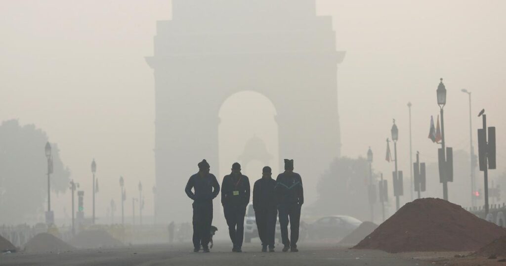
Delhi and Gurugram are witnessing one of their coldest winters in decades. On Tuesday, Gurugram remained in the grip of severe cold, just a day after recording 0.6°C. This marked the city’s lowest temperature in nearly 50 years. Meanwhile, Delhi shivered at a minimum of 3°C. Surprisingly, both cities turned colder than several Himalayan hill stations, including Shimla.
According to the India Meteorological Department (IMD), Gurugram logged 0.6°C on Monday morning. This matched the record low seen on January 22, 1977. Such extreme cold remains rare for the city. In fact, Gurugram has dropped below this level only three times on record. The city saw -0.4°C on December 5, 1966, 0°C on January 11, 1970, and 0.3°C on January 22, 1979.
Meanwhile, temperatures across the hills stayed relatively higher. On the same day, Kangra and Palampur in Himachal Pradesh recorded 3°C. Jammu reported 3.4°C. Uttarakhand’s Mukteshwar, Jolly Grant, and Tehri stood at 4.1°C each. In contrast, Shimla remained much warmer at 8.8°C, while Mussoorie recorded 7.7°C.
So why are the plains colder than the hills this winter?
First, weather systems have played a key role. An active western disturbance has brought cloud cover over the higher reaches of the Himalayas. As a result, clouds trapped heat during the night. This prevented temperatures from falling sharply in hill stations. IMD Director General M Mohapatra explained that cloudy nights reduced heat loss in elevated areas.
In contrast, the plains faced clear skies. Clear conditions allowed rapid heat loss after sunset. At the same time, cold northwesterly winds continued to sweep across northwest India. Together, these factors caused strong radiative cooling. Consequently, temperatures in Delhi, Gurugram, and nearby regions plunged.
Across the National Capital Region, the cold wave tightened its grip. Delhi’s Safdarjung station recorded 3°C. Elsewhere, Hisar dipped to 2.6°C. Amritsar fell to 1.1°C. Churu recorded 1.3°C, Karnal 3.5°C, and Meerut 4.5°C. These readings highlighted how intensely the cold settled over the plains.
The impact became visible on the ground. On Monday morning, frost covered crops, grass, and car windshields across Gurugram and its outskirts. Fog reduced visibility on roads, especially on elevated stretches.
Residents described the conditions as harsh. Jeeva Thavasiraj, a 22-year-old site engineer from Sector 66, said the cold felt unreal. He shared that even heavy safety shoes failed to protect workers from numbness. Similarly, Sunita Devi, a daily commuter from Sohna, said frost coated bus windshields and nearby fields. She added that dense fog forced vehicles to move slowly.
Meanwhile, IMD has kept warnings in place. The department extended an orange alert till January 13. It warned of cold wave to severe cold wave conditions, dense fog, and ground frost across parts of Delhi, Haryana, and neighbouring states.
Health officials have urged caution. Prolonged exposure may cause frostbite, flu, and breathing problems. Elderly people and children remain most vulnerable. Authorities have also advised motorists to avoid early-morning travel due to poor visibility.
Looking ahead, relief may take time. IMD expects temperatures to remain abnormally low for the next few days. However, a gradual rise of 2 to 4°C may follow later. Meteorologists attribute the cold to western disturbances, upper-air cyclonic circulation, and strong westerly winds. A fresh western disturbance from January 15 may finally bring cloud cover and ease conditions.
Adding to the severity, this winter has stayed unusually dry. Northwest India recorded a rainfall deficit of over 84 percent in December and early January. As a result, hills saw little snowfall, further shaping this unusual cold pattern.