
Cyclone Ditwah triggers red alert across Tamil Nadu as landfall nears
Tamil Nadu–Puducherry – Cyclone Ditwah advanced steadily toward the north Tamil Nadu–Puducherry coast on Saturday. As the system intensified over the southwest Bay of Bengal, the India Meteorological Department (IMD) issued a red alert for several districts. Heavy rain, strong winds and the threat of flooding now pose serious risks across Tamil Nadu, Puducherry, Kerala and Telangana.
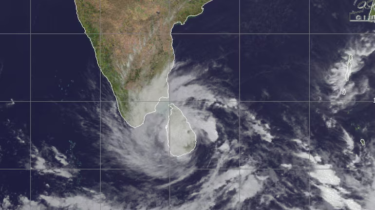
To understand the emerging danger, IMD officials outlined the cyclone’s trajectory. They said the storm hovered near Sri Lanka through Friday before drifting north-northwest. By Saturday morning, it began moving toward Tamil Nadu and Puducherry. IMD chief Dr. Mrutyunjay Mohapatra explained that the system would exit Sri Lanka completely by early Saturday and enter the open waters of the Bay of Bengal. He added that the cyclone could strengthen slightly as it approached the Indian coastline.
As the storm advanced, weather stations recorded widespread rain bands. Consequently, the Regional Meteorological Centre imposed a red alert in Cuddalore, Mayiladuthurai, Villupuram, Chengalpattu and Puducherry. These regions face the highest risk of extremely heavy rainfall. Authorities urged residents to stay indoors, monitor official advisories and avoid low-lying areas.
Meanwhile, IMD forecast extremely heavy rain along coastal Tamil Nadu through Saturday. Many other districts could see heavy to very heavy downpours, while some inland areas may receive moderate showers. The agency also warned of gale winds reaching 70–80 kmph and surging to 90 kmph near landfall. These winds threaten to uproot trees, topple hoardings and damage thatched or mud houses.
Moreover, the storm may cause significant harm to standing crops. Farmers growing vegetables, horticulture plants and flowering crops—especially those in the ripening stage—face steep losses. Officials advised farmers to take protective measures where possible.
As the cyclone moves closer to the coast, IMD warned of urban flooding. Cities with poor drainage could witness rapid waterlogging. In hilly zones, sudden bursts of rainfall could trigger flash-flood-like conditions. Emergency teams began preparing for rescue operations, while district administrations identified vulnerable pockets.
On Sunday, the storm will continue to lash north coastal Tamil Nadu and Puducherry with extremely heavy rain as it approaches landfall. Once the system weakens, rainfall intensity will gradually drop. IMD expects light to moderate rain across many districts on December 1, though isolated areas may still experience heavy showers.
The cyclone’s effects are not limited to Tamil Nadu alone. Kerala will see light to moderate rain at numerous places on Saturday, along with isolated heavy bursts. In coastal Andhra Pradesh, Yanam and Rayalaseema, IMD predicted widespread rain on Saturday and even more intense downpours on Sunday. Telangana is also likely to face heavy rainfall at isolated locations on Sunday as the system moves inland.
As the region braces for the storm, authorities repeated a clear message: stay alert, stay indoors and follow official warnings. Continuous updates from weather agencies will guide the public as Cyclone Ditwah edges toward landfall.